 BikeOtter
How to get water stops and cafés onto a Wahoo ELEMNT route
Why the fountain you planned around often isn't on the unit, what Wahoo has announced for its newer units, and a way that works on older ones too.
A stop only shows on the ELEMNT if it is inside the route file the unit receives. For the ACE, BOLT 3 and ROAM 3, Wahoo has announced support for waypoints in routes synced from Komoot, Ride with GPS and Strava, each with its own rules. Whether they actually show up depends on the unit, its firmware and how the route was made, so check on your unit before a ride that depends on them. On any ELEMNT, you can also add the stops to the route on your phone and send it over Bluetooth, where they appear as markers on the unit's map.
Why don't the stops I planned show on my ELEMNT?
Usually because they never made it into the route file. Three common reasons:
- They were on the planner's map, not in the route. Route planners show cafés, fountains and shops on their map. Unless you add one to the route as a waypoint, it isn't part of the route and isn't sent. Wahoo's help says the same: points on the planner's base map that weren't included in the route don't appear.
- The export dropped them. Komoot's help says its GPX download contains only the route line; waypoints you added while planning are not included.
- The route took a path that doesn't carry them. Wahoo's waypoint article covers routes synced from the three route services. It notes that routes imported as a file through the Wahoo app don't currently get matching waypoint icons.
What has Wahoo announced for waypoints?
Wahoo's help page describes waypoints for the ACE, BOLT 3 and ROAM 3 on firmware 301724 or later. They are meant to show on the map, in the cue sheet and on a Waypoints page, with an icon, a name and the distance to go. Each route service has its own rules:
- Komoot: points of interest from Komoot's map that you added to the tour as waypoints. Custom names or descriptions you edited are not passed on.
- Ride with GPS: points of interest and custom waypoints, as long as they are included in the route file.
- Strava: custom waypoints made in Strava's route builder in a desktop browser. Strava routes synced before the firmware update need to be removed and synced again.
The article covers the third-generation units only. It doesn't describe waypoints on the original ELEMNT, BOLT 1 and 2, or ROAM 1 and 2. And it depends on everything lining up: the firmware, the route service, how you added the stop, and how the route reached the unit. Send a short test route with one stop on it before a long day that relies on it.
What can I do on an older ELEMNT?
If you use the official sync on a BOLT 1 or 2 or ROAM 1 or 2, the practical workarounds are low-tech:
- Route through the stop. Add the fountain or café as a via point in the planner, so the line passes it. You won't get a marker, but you'll ride past it.
- Know the distance. Note the kilometre of each stop and watch the distance field. A few numbers on tape on the stem work.
- Put the stops in the file and send it another way. See below.
How do I add water stops to a route on my phone?
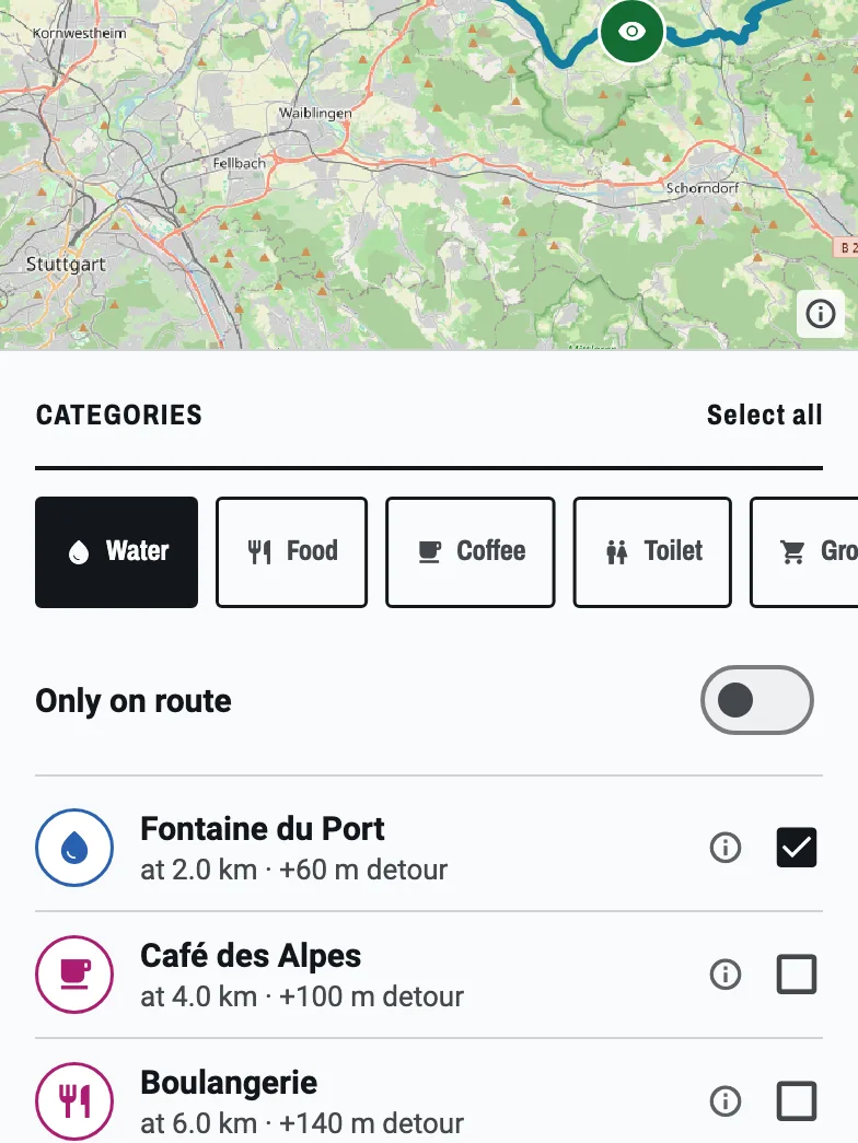

BikeOtter treats stops as part of the route. When it sends a route to the ELEMNT, the stops go with it as course points, the standard place for them in a route file, and the unit draws them on its map with the route.
There are three ways to get stops onto a route in BikeOtter:
- Import a file that has them. Waypoints in a GPX file are kept and become stops, matched to the nearest point on the line.
- Find them along the route. Pick a category (water, food, coffee, toilets, groceries, bike shop, pharmacy or viewpoint) and BikeOtter searches OpenStreetMap along the whole route. Each result shows where it is (
at 42.1 km,+120 m detour, left or right), and whether it will be open when you get there, worked out from your planned start and pace. Tick the ones you want and add them in one go. - Drop one by hand. Tap the map and choose New POI here, or tap an existing stop to edit it.
Then tap Send. The push goes over Bluetooth, so it works with no signal. You can also plan the route in the browser first: the web planner has the same search for stops along the route when you're signed in.
Sending a route, with whatever stops it already carries, is free. Searching for stops and adding or editing them is part of BikeOtter Plus, with a few free goes so you can try it on your own route. The feature book has more on the stop search.
Troubleshooting
- Check that the stops are in the file. Open the GPX in a text editor. Stops are
<wpt>entries. If there are none, the planner didn't export them. - Count them before you send. BikeOtter counts turn cues separately from stops, so a Komoot route reads as "3 stops", not "210 points". If the count is zero, add them before sending.
- Third-generation unit, synced route, no waypoints. Check the firmware version, check that the stop was added the way that service requires, and for Strava, re-sync the routes as Wahoo describes.
- A stop sits on the road, not at the fountain. Stops found in BikeOtter keep their real position from OpenStreetMap, so a fountain 60 m off the road is drawn where the water is. Check hand-placed ones on the map before you send.
Which way should I use?
On a third-generation unit with a route service you already use, try the official waypoints with a short test route first, and keep using them if they show up on your unit. On an older ELEMNT, or when you want stops chosen by what is open on the day, add them on the phone and send the route directly. If the route won't reach the unit at all, start with routes not syncing.
Related guides
Where these steps were checked
The official steps above follow the vendors' own help pages as of 25 Oct 2026. Menus move between app versions. If a step here no longer matches what you see, send a note to support and the guide gets fixed.