 BikeOtter
Why does my Komoot GPX show different elevation elsewhere?
The heights in a GPX file, the elevation model an app looks up, and the way it adds up the rises all differ. None of them is a bug, and you can check which one you're seeing.
Because the climbing figure depends on two things that every app does its own way: where the heights come from, and how the rises are added up. A Komoot GPX carries a height for each point. Some apps use those heights as they are, others look up their own from an elevation model, and each one filters out small bumps differently. On one and the same file, the total can move by 10 percent or more just from how it is counted. A climb that only appears in one app is usually a problem in the heights themselves, and you can check that.
What elevation is in a Komoot GPX file?
Komoot's help says a GPX export contains the route geometry and leaves out waypoints, voice navigation and maps. In the Komoot exports checked for this guide, every track point also carried a height (the <ele> value in the file). So a planner or bike computer that reads the file gets Komoot's heights along with the line.
Those heights are fixed when you download the file. Komoot's elevation data can change after that: its 2026 release notes mention new elevation data for its 3D maps. One Komoot export from 2024 that we checked had a three-kilometre stretch sitting 12 to 30 metres higher than Komoot's current profile of the same tour, and higher than the public SRTM and EU-DEM elevation models too. Any app drawing that file showed a climb that Komoot itself no longer shows. If a profile looks wrong, export the tour again and compare.
Why does each app count a different total?
Even with identical heights, "total climbing" isn't one number. It depends on how small a rise still counts.
- Adding every rise. Each tiny step up between two points is counted. On noisy data, that inflates the total.
- Ignoring small bumps. Strava's help says climbing has to continue for more than 10 metres to count on activities without strong barometric data, and more than 2 metres with it. BRouter, the open-source router, reports a "filtered ascend" that leaves out noise and small hills on purpose.
- Smoothing. Ride with GPS says it smooths recorded elevation and lands within about 10 percent of a barometric Garmin.
To show the size of this, take one 88 km Komoot tour and its own exported heights. Adding every rise gives about 1220 m. Counting only rises of 10 m or more gives about 1010 m. Same file, same heights, a 200 m difference.
Where else do the heights come from?
- Elevation models. Strava's route builder uses its own elevation database, and for devices without a barometric altimeter it compares your track to a basemap. Garmin Connect uses Garmin's elevation model (DEM) for devices without a barometer. Ride with GPS uses SRTM, a satellite model on a grid of about 90 metres. BRouter uses SRTM, and Lidar data in the far north of Europe.
- Bike computers. Wahoo says the ELEMNT measures elevation with a barometric altimeter, corrected with GPS at the start of a ride. Garmin's Edge units use a barometric altimeter too. A barometer reacts to weather and to wind on the sensor, so a recorded ride rarely matches the planned figure exactly.
A coarse model also gets bridges and tunnels wrong. It knows the ground, not the road, so a bridge over a valley shows a dip down and back up, and a tunnel shows the whole mountain on top of it. Ride with GPS has a tool to flatten such a section for exactly this reason.
How do I find out which figure is right?
- Compare like with like. Planned route against planned route in the same app, or ride against ride. A planned total and a recorded total are measured differently.
- Look at the profile, not the total. If the shape matches and only the number differs, it's the counting. If one profile has a climb the other doesn't, it's the heights.
- Check the file. Open the GPX in a text editor and look for
<ele>on the track points. If they are missing, every app fills them in from its own model, and the totals will differ more. - Download it fresh. For an old export, download the tour from Komoot again and see if the strange climb is gone.
- Use the tools. For recorded rides, Strava offers Correct Elevation on the web for barometric data, Garmin Connect has Change Elevation Source on the web, and Ride with GPS has Replace Elevation.
How does BikeOtter count climbing?
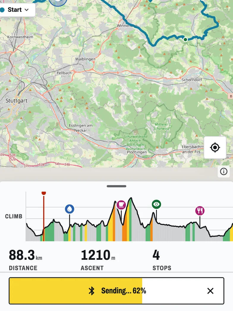
Plainly, so you can predict it. BikeOtter keeps the heights that come with a route and doesn't swap in its own:
- An imported GPX or FIT file keeps the file's own heights, point for point. The profile draws them as they are, and nothing replaces them with a terrain model.
- A route planned in BikeOtter gets its heights from BRouter, which uses SRTM.
- The climbing figure adds up every rise between neighbouring points, without a threshold. On a noisy file it reads higher than a smoothed figure, and it will often be a little above Komoot's.
So if a profile in BikeOtter shows a climb you don't believe, it's in the file. Download the tour again or compare the source. Drag along the profile to see the climbing up to any point. More on planning in the feature book and the web planner.
Which figure should I use?
For pacing and food, use the planner you trust and stick with it, so your sense of "1000 m" stays the same from one ride to the next. For a race or event, use the organiser's figure. When two apps disagree by a few percent, it's the counting. When a climb exists in only one of them, check the file. If the tour won't reach your unit at all, see Komoot route not on Wahoo or Garmin course not syncing.
Related guides
Where these steps were checked
The official steps above follow the vendors' own help pages as of 25 Oct 2026. Menus move between app versions. If a step here no longer matches what you see, send a note to support and the guide gets fixed.
- Komoot: Export and import Routes and Activities
- Komoot: All komoot Feature Releases, 2026
- Strava: Elevation on Strava FAQs
- Strava: Elevation
- Garmin: How Do I Change the Elevation Source in Garmin Connect?
- Ride with GPS: Grade, Elevation, and GPS Accuracy FAQ
- BRouter: Elevation (project documentation)
- Wahoo: Why are there Elevation differences in my ride data?